


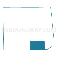
LIBERTY TWP Voting District, Tioga County, Pennsylvania
About
Outline

Summary
| Unique Area Identifier | 664010 |
| Name | LIBERTY TWP Voting District |
| County | Tioga County |
| State | Pennsylvania |
| Area (square miles) | 64.67 |
| Land Area (square miles) | 64.64 |
| Water Area (square miles) | 0.04 |
| % of Land Area | 99.94 |
| % of Water Area | 0.06 |
| Latitude of the Internal Point | 41.58537090 |
| Longtitude of the Internal Point | -77.11771810 |
Maps

Graphs
Select a template below for downloading or customizing gragh for LIBERTY TWP Voting District, Tioga County, Pennsylvania


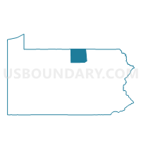
Neighbors
Neighoring Voting District (by Name) Neighboring Voting District on the Map
- BLOSS TWP Voting District, Tioga County, PA
- HAMILTON TWP Voting District, Tioga County, PA
- JACKSON TWP Voting District, Lycoming County, PA
- LIBERTY Voting District, Tioga County, PA
- MORRIS TWP Voting District, Tioga County, PA
- PINE TWP Voting District, Lycoming County, PA
- UNION TWP VTD NORTH, Tioga County, PA
- UNION TWP VTD SOUTH, Tioga County, PA
Top 10 Neighboring County Subdivision (by Population) Neighboring County Subdivision on the Map
- Liberty township, Tioga County, PA (1,042)
- Union township, Tioga County, PA (1,000)
- Morris township, Tioga County, PA (606)
- Hamilton township, Tioga County, PA (499)
- Jackson township, Lycoming County, PA (396)
- Bloss township, Tioga County, PA (353)
- Pine township, Lycoming County, PA (294)
- Liberty borough, Tioga County, PA (249)
Top 10 Neighboring Place (by Population) Neighboring Place on the Map
Top 10 Neighboring Unified School District (by Population) Neighboring Unified School District on the Map
- Southern Tioga School District, PA (15,719)
- Wellsboro Area School District, PA (11,793)
- Canton Area School District, PA (6,531)
Top 10 Neighboring State Legislative District Lower Chamber (by Population) Neighboring State Legislative District Lower Chamber on the Map
Top 10 Neighboring State Legislative District Upper Chamber (by Population) Neighboring State Legislative District Upper Chamber on the Map
Top 10 Neighboring 111th Congressional District (by Population) Neighboring 111th Congressional District on the Map
Top 10 Neighboring Census Tract (by Population) Neighboring Census Tract on the Map
- Census Tract 9507, Tioga County, PA (5,251)
- Census Tract 9505, Tioga County, PA (4,559)
- Census Tract 9510, Tioga County, PA (3,105)
- Census Tract 101, Lycoming County, PA (2,339)
Top 10 Neighboring 5-Digit ZIP Code Tabulation Area (by Population) Neighboring 5-Digit ZIP Code Tabulation Area on the Map
- 16901, PA (10,243)
- 16912, PA (1,776)
- 16930, PA (1,300)
- 17765, PA (1,162)
- 16938, PA (747)
- 16911, PA (332)
- 17776, PA (295)